Pollution Risk in Agricultural Areas of the Huaquechula Sub-Basin
DOI:
https://doi.org/10.28940/terralatinoamericana.v43i.2174Keywords:
accumulation, pollutants, risk, Puebla, rivers, soilAbstract
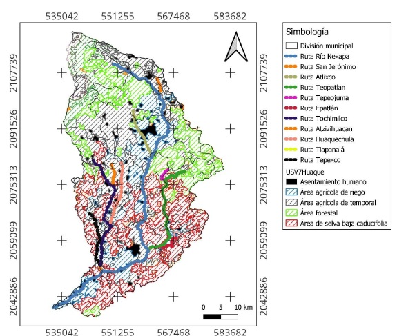
The impact of river water pollution on irrigated agricultural production systems is related to the accumulation of pollutants in the soil. The main objective of this study was to perform a spatial analysis of Nexapa River pollution and the risk it poses to agricultural lands near the river. The WASP model was used to simulate the transport and concentration of total nitrogen, nitrate, total phosphorus, cadmium, chromium, and lead in the Nexapa River. A spatial analysis was performed using the model estimates and the land-use and vegetation map to identify the agricultural areas most at risk of contamination from wastewater discharges. The highest pollutant concentrations estimated with the model were: total nitrogen (20.04 mg L-1), nitrate (7.03 mg L-1), total phosphorus (2.80 mg L-1), cadmium (0.002 mg L-1), chromium (0.085 mg L-1), and lead (0.009 mg L-1). Two areas of greatest risk to contamination associated with the use of water from the Nexapa River were identified: one in southern Atlixco and the other in northern and southern Izúcar de Matamoros. A limitation of the modeling was the unavailability of point source discharge data and the lack of access to discharge facilities for wastewater sampling; therefore, samples were taken at the river discharge sites. This study is pioneering in river modeling in the Puebla Valley. It is concluded that the WASP model is a useful tool for analyzing the spatial and temporal dynamics of pollutant concentrations in the Nexapa River and for predicting potential contamination risk areas and the need for intervention measures in the Huaquechula sub-basin.
Downloads