Update of Soil Classification Scale 1:50 000 in the State of Mexico
DOI:
https://doi.org/10.28940/terra.v42i0.1795Keywords:
world reference base, properties, classification systems, unitsAbstract
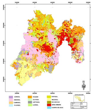
The updating of edaphological cartography provides soil information for agricultural and livestock planning and the implementation of regional development programs. The objectives of this study were: 1) to classify and update the 1:50 000 edaphological cartography of the State of Mexico and 2) to identify the changes in the soil units according to the FAO (Food and Agriculture Organization)-WRB (World Reference Base) classification. The 1:50 000 edaphological cartography of the State of Mexico was digitalized; soil units were identified and their databases were created. Field work was carried out for soil verification and sampling; the soil classification was updated based on the 1988 FAO version and the 2006 and 2022 versions of the WRB. Soils with the largest surface area in the State of Mexico are Andosols with 479 908 ha, Phaeozems with 476 768 ha, Vertisols with 317 503 ha, Regosols with 265 683 ha and Cambisols with 196 047 ha. The soil units that underwent changes in nomenclature were Lithosoles, Ranker and Rendzinas, which corresponded to Lithic Leptosols, Umbric Leptosols and Rendzic Leptosols in the 2022 version.
Downloads
Publication Facts
Reviewer profiles N/A
Author statements
- Academic society
- Terra Latinoamericana
- Publisher
- Mexican Society of Soil Science, C.A.
