Analysis of Land Cover and Land Use in the Lower Usumacinta River Basin Using Remote Sensing Techniques
DOI:
https://doi.org/10.28940/terralatinoamericana.v43i.2075Keywords:
classification, normalized dif ference vegetation index, spectral index, digital elevation model, natural resourcesAbstract
The drivers of land use change at various scales pose a threat to the stability of tropical ecosystems, af fecting both biodiversity and essential ecosystem services. These changes are particularly critical in areas such as the Lower Usumacinta River
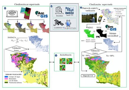
Basin (LURB), a region of ecological and cultural value. In this context, our study aims to classify land cover and land use (LCLU) in the LURB using Landsat 8 OLI satellite imagery. Two classification methods were employed: the ISODATA algorithm for unsupervised classification (USC) and the Maximum Likelihood Classification (MLC) algorithm for supervised classification (SC). The unsupervised classification grouped the pixels based on spectral distance, identifying four general classes: wetlands, anthropogenic activities, tree vegetation, and water bodies, with a moderate accuracy of 67% and a kappa index of 0.51. In contrast, the supervised classification, using 948 training points and auxiliary data derived from the Normalized Dif ference Vegetation Index (NDVI) and the Digital Elevation Model (DEM), provided more detailed mapping, discriminating specific classes such as agriculture (41.46%), wetlands (21.17%), commercial forest plantations (4.09%), and urban areas (0.56%), achieving a kappa index of 0.90, validated with 330 ground control points. Our results show that the integration of NDVI and DEM data significantly improved spectral discrimination of tropical forest cover and wetlands, while the unsupervised classification exhibited limitations in dif ferentiating specific classes such as tropical forests, flooded forests, and oil palm plantations. Our findings highlight the importance of using up-to-date satellite imagery, along with auxiliary data and robust algorithms, to achieve more accurate LCLU classification, which is essential for land planning, natural resource management, and biodiversity conservation in the LURB.
Downloads
Publication Facts
Reviewer profiles N/A
Author statements
- Academic society
- Terra Latinoamericana
- Publisher
- Mexican Society of Soil Science, C.A.
