Analysis of Land Cover and Land Use in the Lower Usumacinta River Basin Using Remote Sensing Techniques

Authors

  • Héctor Javier Megia-Vera Universidad Juárez Autónoma de Tabasco y Tecnologico Nacional de México Campus Villa La Venta https://orcid.org/0000-0001-6499-5404
  • Candelario Peralta-Carreta Universidad Juárez Autónima de Tabasco y Centro del Cambio Global y la Sustentabilidad, A.C. https://orcid.org/0000-0002-5747-9791
  • Ojilve Ramón Medrano-Pérez CONAHCyT-Tecnológico Nacional de México/Instituto Tecnológico Superior de Misantla https://orcid.org/0000-0002-5445-1136
  • Miguel Ángel Palomeque-De la Cruz División Académica de Ciencias Biológicas. Universidad Juárez Autónoma de Tabasco
  • Rodimiro Ramos-Reyes El Colegio de la Frontera Sur, Unidad Villahermosa https://orcid.org/0000-0003-3957-8160
  • Adalberto Galindo Alcantara División Académica de Ciencias Biológicas. Universidad Juárez Autónoma de Tabasco https://orcid.org/0000-0001-9628-982X

DOI:

https://doi.org/10.28940/terralatinoamericana.v43i.2075

Keywords:

classification, normalized dif ference vegetation index, spectral index, digital elevation model, natural resources

Abstract

The drivers of land use change at various scales pose a threat to the stability of tropical ecosystems, af fecting both biodiversity and essential ecosystem services. These  changes  are  particularly  critical  in  areas  such  as  the Lower Usumacinta River
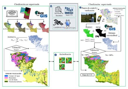
Basin (LURB), a region of ecological and cultural value. In this context, our study aims to classify land cover and land use (LCLU) in the LURB using Landsat 8 OLI satellite imagery. Two classification methods were employed: the ISODATA algorithm for unsupervised classification (USC) and the Maximum Likelihood Classification (MLC) algorithm for supervised classification (SC). The unsupervised classification grouped the pixels based on spectral distance, identifying four general classes: wetlands, anthropogenic activities, tree vegetation, and water bodies, with a moderate accuracy of 67% and a kappa index of 0.51. In contrast, the supervised classification, using 948 training points and auxiliary data derived from the Normalized Dif ference Vegetation Index (NDVI) and the Digital Elevation Model (DEM), provided more detailed mapping, discriminating specific classes such as agriculture (41.46%), wetlands (21.17%), commercial forest plantations (4.09%), and urban areas (0.56%), achieving a kappa index of 0.90, validated with 330 ground control points. Our results show that the integration of NDVI and DEM data significantly improved spectral discrimination of tropical forest cover and wetlands, while the unsupervised classification exhibited limitations in dif ferentiating specific classes such as tropical forests, flooded forests, and oil palm plantations. Our findings highlight the importance of using up-to-date satellite imagery, along with auxiliary data and robust algorithms, to achieve more accurate LCLU classification, which is essential for land planning, natural resource management, and biodiversity conservation in the LURB.

Downloads

Download data is not yet available.

Publication Facts

Metric
This article
Other articles
Peer reviewers 
2
2.4

Reviewer profiles  N/A

Author statements

Author statements
This article
Other articles
Data availability 
N/A
16%
External funding 
N/A
32%
Competing interests 
N/A
11%
Metric
This journal
Other journals
Articles accepted 
48%
33%
Days to publication 
262
145

Indexed in

Editor & editorial board
profiles
Academic society 
Terra Latinoamericana

Author Biographies

Héctor Javier Megia-Vera, Universidad Juárez Autónoma de Tabasco y Tecnologico Nacional de México Campus Villa La Venta

Research professor at the Tecnológico Nacional de México Campus Villa La Venta and PhD student in Sciences in Ecology and Management of Tropical Systems (PNPC) at the Juárez Autonomous University of Tabasco, developing studies with spatial dynamics and multicriteria analysis, based on remote sensing and geographic information systems.

Candelario Peralta-Carreta, Universidad Juárez Autónima de Tabasco y Centro del Cambio Global y la Sustentabilidad, A.C.

Master in Environmental Sciences, interested in the analysis of satellite images and those obtained with drones, for monitoring the loss of vegetation cover, determining changes in land use, landscape ecology, river morphodynamics, determining flood zones and agroecological zoning. I have certifications for the use of unmanned aircraft for professional use, experience in photogrammetry, data collection and processing in the field, coordination of work groups, budget management and project management. I have participated in transdisciplinary projects related to current socio-environmental challenges and sustainable territorial management (e.g. management plans, risk atlases, ecological regulations, etc.)

Ojilve Ramón Medrano-Pérez, CONAHCyT-Tecnológico Nacional de México/Instituto Tecnológico Superior de Misantla

Researcher for Mexico CONAHCYT-TecNM / ITS Misantla-Veracruz. Researcher for Mexico CONAHCYT- TecNM / ITS Misantla-Veracruz Dr. (Hydrology and Management Water Resources)

Miguel Ángel Palomeque-De la Cruz, División Académica de Ciencias Biológicas. Universidad Juárez Autónoma de Tabasco

Graduate in Biology, Master in Environmental Sciences and Doctor of Science in Ecology and Management of Tropical Systems belonging to the Academic Body of Ecological Planning and Socio-environmental Analysis in the Academic Division of Biological Sciences, Juárez Autonomous University of Tabasco. It is part of the National System of Researchers Level 1 of Area V Social Sciences and is a Member of the State System of Researchers. His Line of Research is Territorial Ecological Planning. Interests in urban studies, Geographic Information Systems, Environmental Remote Sensing, Geomatics. During 2017 to the present, he has collaborated on a project on watershed management and a metropolitan urban development program for Villahermosa, an irrigation Atlas. He has been coordinator of a National Socio-Environmental Impact Project. It has 26 scientific publications on urban planning, land use change, geomatic models and bovine livestock, meteorological monitoring and the teaching of courses on ecosystem restoration, remote sensing, project formulation, geomatic models of land use change, analysis of environmental irrigation and multicriteria evaluation.

Rodimiro Ramos-Reyes, El Colegio de la Frontera Sur, Unidad Villahermosa

Researcher, Department of Observation and Study of the Earth, the Atmosphere and the Ocean, Group: Ecology, landscape and Sustainability, Attached to ECOSUR, Villahermosa Unit. I have taught postgraduate courses related to geographic information systems and vulnerability. I collaborate on work related to my line of research on remote sensing, land use changes, wetland classification, flooding, vulnerability and climate change in coastal areas. I am a referee in scientific and popular magazines, as well as a member of the editorial committee of Diálogos Magazine, I have published 35 articles. I belong to the State System of Researchers of Tabasco and also to the National System of Researchers Level 1. https://orcid.org/0000-0003-3957-8160.

Adalberto Galindo Alcantara, División Académica de Ciencias Biológicas. Universidad Juárez Autónoma de Tabasco

Researcher and has participated as director and collaborator in more than 50 projects financed by various sources. In the area of ​​environmental sciences, the most important projects he has directed are: The Ecological Planning program of the State of Tabasco (Sedespa, 2006), The Risk Atlas of the Municipality of Centro (2009 and 2015); The Risk Strategy of the State of Tabasco (EGIR, Sotop, 2015); Cultural Tourism Potential of the Historic Center of the City of Villahermosa (Fomix, 2011) and the Metropolitan Development Program of the Metropolitan Zone of the City of Villahermosa (2018).

Published

2025-04-30

How to Cite

Megia-Vera, H. J., Peralta-Carreta, C., Medrano-Pérez, O. R., Palomeque-De la Cruz, M. Ángel, Ramos-Reyes, R., & Galindo Alcantara, A. (2025). Analysis of Land Cover and Land Use in the Lower Usumacinta River Basin Using Remote Sensing Techniques. REVISTA TERRA LATINOAMERICANA, 43. https://doi.org/10.28940/terralatinoamericana.v43i.2075

Issue

Section

Scientific Papers

Metrics

Most read articles by the same author(s)